
Each map on this page shows where one animal lives in the wild. Spin it as a globe or flatten it into a world map, see the range the animal has lost and find the places where people have moved it back. Type a country into the search box and the map tells you whether the animal lives there.
Habitat maps
-
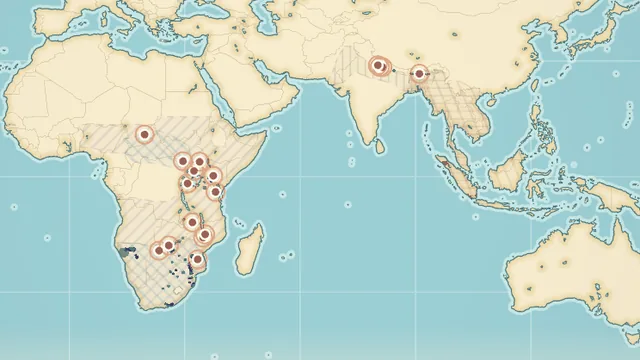
Rhino Habitat Map
All five rhino species: the parks where each one lives today and the former range it lost across Africa and Asia.
-
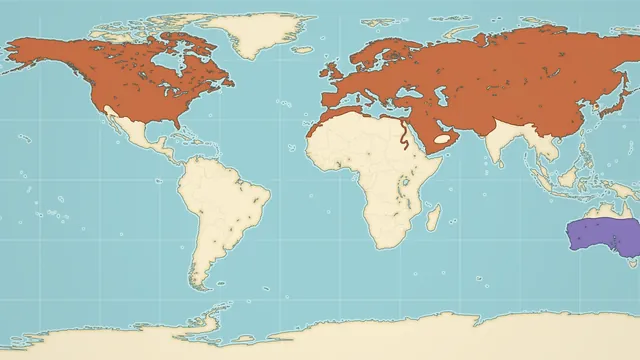
Red Fox Habitat Map
The largest natural range of any wild carnivore, plus the introduced population that covers most of Australia.
-
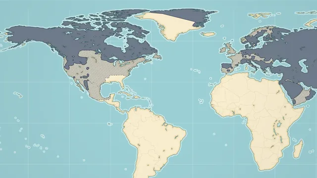
Gray Wolf Habitat Map
Where gray wolves live now, where they were wiped out and where they have been brought back.
-
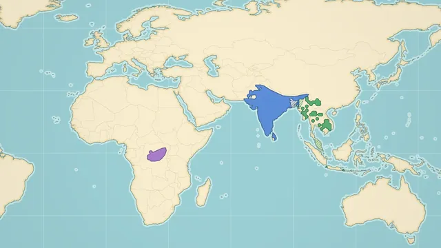
Peacock Habitat Map
The native ranges of the Indian, green and Congo peafowl, and the places where escaped peacocks now live wild.
What each map shows
- Rhinos: all five living species, each in its own colour. White and black rhinos live in eastern and southern Africa, and the greater one-horned, Javan and Sumatran rhinos live in South and Southeast Asia. About 26,700 rhinos remain in the wild, more than half of them in South Africa. Hatched areas show the former range and orange pins mark the parks where rhinos were moved back.
- Red foxes: the native range across North America, Europe, Asia and North Africa, close to 70 million square kilometers, which is larger than that of any other wild carnivore. A second colour shows Australia, where people released foxes around 1871 and where they now cover about three quarters of the mainland.
- Gray wolves: the current range in Canada, Alaska, parts of the lower 48 states, Europe and Asia, the much larger range wolves were wiped out of, and pins for reintroductions and natural returns. About 200,000 to 250,000 gray wolves remain in the wild.
- Peacocks: the native ranges of the three peafowl species. The Indian peafowl lives in South Asia, the green peafowl in Southeast Asia and the Congo peafowl in one block of central African rainforest. Coral dots mark the places where escaped peacocks now live wild.
How to use the maps
- Move: drag to rotate the globe. Scroll or pinch to zoom.
- Globe or flat map: the Globe and Flat buttons switch between the two views.
- Legend: tap a layer in the legend to fly to that range and open its fact card. Tap it again to hide it.
- Countries: tap a country on the map, or type its name in the search box, to find out whether the animal lives there. The gray wolf and red fox maps also answer for every US state and Canadian province.
- Download and share: save the map as a PNG image or copy a link to it.
For a closer look at the animals themselves, the animal 3D models let you turn a peacock and a rhinoceros around and tap their body parts.
Frequently asked questions
Where does the range data come from?
From published range assessments, wildlife surveys and sighting records, including the IUCN Red List and the GBIF species database. The rhino map uses the population counts in the International Rhino Foundation’s State of the Rhino 2025 report. The guide under each map lists its sources.
Can I use the maps for school?
Yes. The maps are free and need no account. The download button saves an image with the map title, the legend and the data sources, ready for a report or a slide.
Do the maps work on a phone?
Yes. Every control works with touch, and each map opens at a view sized to the screen.